This post is based on the original Facebook post from 15th July 2020.
Maps are fundamental archival materials for the history of ethnicity as well as their rights. More importantly, it protects the property of the citizens, territorial borders and geographical infrastructure of a municipality, county and country.
«Kartverket» is the Norwegian governmental body that has dealt with maps of Norway since 1773
https://www.kartverket.no/en/
The centre of maps at the Nasjonal library of Norway has an archive of maps of Norway, Nordic and northern parts. Det oldest map in their archive is from 1482.
https://www.nb.no/kartsenteret/
They have preserved «collections» of maps.
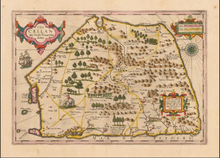
Here is a post by Norway based Sarawanan Komathi Nadarasa who has collected old maps of Sri Lanka in high resolution. This is an example of «collection» (a type of private archive) based on a specific format (map) and topic (Sri Lanka). In the picture, there is the map of Thirukonamalai (Trincomalee) from 1590. Drawn by Jodocus Hondius. However, he mentions that some claim this to be from 1620. The original material is in Amsterdam.
Likewise, many Tamils are doing such collections based on various formats and topics. Normally related to Sri Lanka.
Disclaimer:
Due to the lack of or fragmented archives or limited access to archives in Tamil society, it has been challenging to get access to available sources that can support oral history interviews.
In this situation, writing about diaspora Tamil history will be a dynamic process which may change its shape and be updated over time. Thus, we welcome the public to provide feedback with any verifiable sources in the case of need for correction in the factual information in this website.
Reproduction of this article is allowed when used without any alterations to the contents and the source, DsporA Tamil Archive, is mentioned.
Updated: 18.10.2020

One thought on “Collection of maps of Eelam”